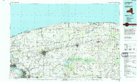
1984 Map of Lockport
USGS Topo · Published 1994About this map
The Niagara Escarpment defines the transition between the lake plains and the higher ground to the south, shaping the path of the regional waterways as they flow toward Lake Ontario. In the early 1980s, the industrial legacy of Niagara Falls and North Tonawanda anchors the southwestern corner of the sheet, while the city of Lockport remains the central hub for the surrounding agricultural landscape. This survey documents the intersection of modern transport and older rural infrastructure, showing the New York State Thruway cutting across the southern tier while the Conrail and Amtrak lines maintain the rail corridor through Medina and Middleport.
Find a feature on this map
79 named features on this map. Tap any name to fly to it.
Don’t see what you’re looking for? This feature index may not catch every label — zoom into the map to look around manually.
Map Details
Editions of this 1984 Lockport Map
2 editions found
Other maps of this area

1894 · Buffalo
USGS Topo · 1:62,500

1894 · Niagara Falls
USGS Topo · 1:62,500

1894 · Wilson
USGS Topo · 1:62,500

1896 · Niagara Falls
USGS Topo · 1:62,500

1897 · Tonawanda
USGS Topo · 1:62,500

1897 · Albion
USGS Topo · 1:62,500

1897 · Olcott
USGS Topo · 1:62,500

1897 · Medina
USGS Topo · 1:62,500

1897 · Lockport
USGS Topo · 1:62,500

1897 · Oak Orchard
USGS Topo · 1:62,500