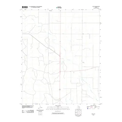
2010 Map of Loco
USGS Topo · Published 2010About this map
Loco and New Loco center this rural landscape in Collingsworth County, where the plains are defined by an intricate network of drainage systems. The map traces the winding course of Buck Creek as it moves across the territory, joined by smaller tributaries like Twin Mill Branch and Gypsum Creek. This topographic study reveals a sparse settlement pattern characteristic of the Texas Panhandle, where life and travel are organized around a grid of county roads and farm-to-market routes. The presence of the Loco Cemetery east of Fm 1438 provides a vital point of reference for genealogists and local historians documenting the families who established themselves in this cattle and farming country. The layout of Fm 1034 and other transit lines shows how these remote outposts remained connected to the larger region during the early 21st century.
Find a feature on this map
14 named features on this map. Tap any name to fly to it.
Don’t see what you’re looking for? This feature index may not catch every label — zoom into the map to look around manually.
Map Details
Editions of this 2010 Loco Map
This is the sole edition of this map. No revisions or reprints were ever made.
Other maps of this area

1954 · Plainview
USGS Topo · 1:250,000

1958 · Plainview
USGS Topo · 1:250,000

1960 · Loco
USGS Topo · 1:62,500

1961 · Estelline
USGS Topo · 1:62,500

1964 · Wellington
USGS Topo · 1:24,000

1964 · Dodson
USGS Topo · 1:24,000

1964 · Rolla
USGS Topo · 1:24,000
1984 · Arlie
USGS Topo · 1:24,000

1984 · Estelline NE
USGS Topo · 1:24,000
1984 · Loco
USGS Topo · 1:24,000