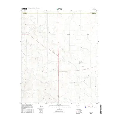
2016 Map of Loco
USGS Topo · Published 2016About this map
Loco stands as the primary settlement in this stretch of the Texas Panhandle, positioned along the border between Collingsworth Co and Childress Co. The landscape is defined by the drainage of Buck Cr and its tributaries, including Twin Mill Br and Gypsum Cr, which carve through the plains. The rural infrastructure of the mid-2010s is clearly visible, with a network of ranch roads like Ranch Rd 1438 and Ranch Rd 1034 connecting isolated homesteads to the village. For those tracing local heritage, the Loco Cem serves as a critical landmark for family history, situated just south of the main community. The map illustrates a contemporary livestock and agricultural landscape where the terrain dictates the path of every road and boundary line.
Find a feature on this map
14 named features on this map. Tap any name to fly to it.
Don’t see what you’re looking for? This feature index may not catch every label — zoom into the map to look around manually.
Map Details
Editions of this 2016 Loco Map
This is the sole edition of this map. No revisions or reprints were ever made.
Other maps of this area

1954 · Plainview
USGS Topo · 1:250,000

1958 · Plainview
USGS Topo · 1:250,000

1960 · Loco
USGS Topo · 1:62,500

1961 · Estelline
USGS Topo · 1:62,500

1964 · Wellington
USGS Topo · 1:24,000

1964 · Dodson
USGS Topo · 1:24,000

1964 · Rolla
USGS Topo · 1:24,000
1984 · Arlie
USGS Topo · 1:24,000

1984 · Estelline NE
USGS Topo · 1:24,000
1984 · Loco
USGS Topo · 1:24,000