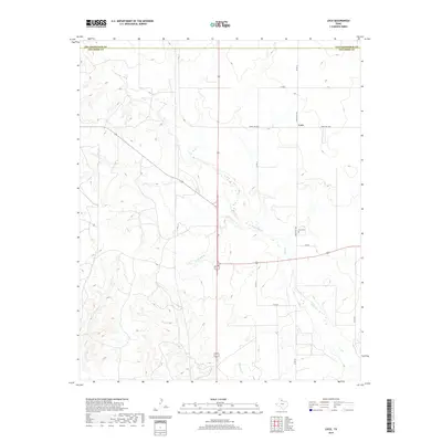
2019 Map of Loco
USGS Topo · Published 2019About this map
Loco sits at the intersection of several ranch and county roads in this portion of the Texas Panhandle, defined by the winding course of Buck Cr. The landscape is etched with seasonal drainages such as Twin Mill Br and Gypsum Cr, reflecting the arid, dissected plains near the border of Collingsworth and Childress counties. For researchers of local history, the Loco Cem remains a primary landmark along Ranch Rd 1438, providing a clear point of reference for the small community's footprint in the modern era. The road network, including Co Rd 16 and Co Rd 8, highlights the grid-like infrastructure that persists across this rural agricultural and ranching region.
Find a feature on this map
14 named features on this map. Tap any name to fly to it.
Don’t see what you’re looking for? This feature index may not catch every label — zoom into the map to look around manually.
Map Details
Editions of this 2019 Loco Map
This is the sole edition of this map. No revisions or reprints were ever made.
Other maps of this area

1954 · Plainview
USGS Topo · 1:250,000

1958 · Plainview
USGS Topo · 1:250,000

1960 · Loco
USGS Topo · 1:62,500

1961 · Estelline
USGS Topo · 1:62,500

1964 · Wellington
USGS Topo · 1:24,000

1964 · Dodson
USGS Topo · 1:24,000

1964 · Rolla
USGS Topo · 1:24,000
1984 · Arlie
USGS Topo · 1:24,000

1984 · Estelline NE
USGS Topo · 1:24,000
1984 · Loco
USGS Topo · 1:24,000