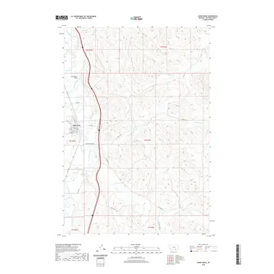
2020 Map of Lodge Grass
USGS Topo · Published 2020About this map
Lodge Grass serves as the primary settlement within this Big Horn County landscape, situated where Lodge Grass Cr meets the broader Little Bighorn Valley. The topography is defined by the winding course of the Little Bighorn River, which anchors a network of seasonal drainages and irrigation infrastructure. The presence of the Fortymile Canal in the southwestern quadrant indicates the vital role of water management for agriculture in this semi-arid region. Away from the river bottom, the terrain rises into dissected coulees and ridges named for local geography and family legacies, including Slaughter Cr, Grey Blanket Cr, and Owl Cr. A grid of rural routes such as Nomee Rd and Old Grey Blanket RD provides access across the high ground, connecting the scattered homesteads and ranching operations to the community center at Lodge Grass.
Find a feature on this map
24 named features on this map. Tap any name to fly to it.
Don’t see what you’re looking for? This feature index may not catch every label — zoom into the map to look around manually.
Map Details
Editions of this 2020 Lodge Grass Map
This is the sole edition of this map. No revisions or reprints were ever made.
Other maps of this area

1894 · Rosebud
USGS Topo · 1:125,000

1901 · Rosebud
USGS Topo · 1:125,000

1954 · Hardin
USGS Topo · 1:250,000

1957 · Hardin
USGS Topo · 1:250,000

1958 · Hardin
USGS Topo · 1:250,000

1967 · Lodge Grass NE
USGS Topo · 1:24,000

1967 · Kid Creek
USGS Topo · 1:24,000

1967 · Wolf Mountain Lookout
USGS Topo · 1:24,000
1967 · Wyola
USGS Topo · 1:24,000
1967 · Benteen
USGS Topo · 1:24,000