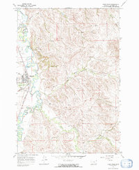
1967 Map of Lodge Grass
USGS Topo · Published 1971About this map
The Lodge Grass community sits within the Crow Indian Reservation, serving as a hub for both transportation and regional activity along the Little Bighorn River. This 1967 survey documents a landscape where the river’s winding course dictates the layout of infrastructure, including the Chicago Burlington and Quincy railroad and the Fortymile Canal. Local social and civic life is anchored by the Indian Center, a central Cem, and a local Water Tank.
Find a feature on this map
27 named features on this map. Tap any name to fly to it.
Don’t see what you’re looking for? This feature index may not catch every label — zoom into the map to look around manually.
Map Details
Editions of this 1967 Lodge Grass Map
2 editions found
Other maps of this area

1894 · Rosebud
USGS Topo · 1:125,000

1901 · Rosebud
USGS Topo · 1:125,000

1954 · Hardin
USGS Topo · 1:250,000

1957 · Hardin
USGS Topo · 1:250,000

1958 · Hardin
USGS Topo · 1:250,000

1967 · Lodge Grass NE
USGS Topo · 1:24,000

1967 · Kid Creek
USGS Topo · 1:24,000

1967 · Wolf Mountain Lookout
USGS Topo · 1:24,000
1967 · Wyola
USGS Topo · 1:24,000
1967 · Benteen
USGS Topo · 1:24,000
Featured Places
- Lodge Grass, MT
- Lodge Grass, Lodge Grass
- Forty Mile Hutterite Colony, MT
- Big Horn County, MT
- United States