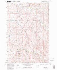
1967 Map of Lodge Grass NE
USGS Topo · Published 1988About this map
Reno Creek and its many winding tributaries define this portion of the Crow Indian Reservation, as documented during a 1967 field check. The landscape is marked by a complex network of seasonal drainages and springs, with Long Otter Creek and Shavings Creek cutting through the dissected terrain. Human activity is sparse but specific to the era, characterized by an isolated Fellows Landing Strip and evidence of resource exploration via a Well and a Drill Hole. This survey captures the region just before significant modern developments, showing a reliance on unimproved paths and a Jeep Trail for navigation across the high ridges. The map provides a look at the hydrography of the Big Horn area, including the upper reaches of Slaughter Creek and the headwaters of the South Fork.
Find a feature on this map
11 named features on this map. Tap any name to fly to it.
Don’t see what you’re looking for? This feature index may not catch every label — zoom into the map to look around manually.
Map Details
Editions of this 1967 Lodge Grass NE Map
3 editions found
Other maps of this area

1894 · Rosebud
USGS Topo · 1:125,000

1901 · Rosebud
USGS Topo · 1:125,000

1954 · Hardin
USGS Topo · 1:250,000

1957 · Hardin
USGS Topo · 1:250,000

1958 · Hardin
USGS Topo · 1:250,000

1967 · Crow Agency SE
USGS Topo · 1:24,000

1967 · Lodge Grass NE
USGS Topo · 1:24,000

1967 · Wolf Mountain Lookout
USGS Topo · 1:24,000
1967 · Benteen
USGS Topo · 1:24,000
1967 · Crow Agency
USGS Topo · 1:24,000