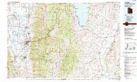
1984 Map of Logan
USGS Topo · Published 1985About this map
Cache Valley serves as the focal point for this mid-1980s topographic study, illustrating the dense agricultural and residential corridor stretching from Logan northward to Richmond and Lewiston. This fertile basin is defined by its sophisticated water management systems, including Cutler Reservoir and the Logan River, which supported the region's burgeoning communities before the turn of the century. To the east, the steep ascent into the Bear River Range and Cache National Forest reveals a landscape dedicated to recreation and conservation, anchored by the turquoise waters of Bear Lake and the Hardware Ranch Wildlife Management Area. The transport network of the Union Pacific railroad and U S Highway 89 highlights the historical transit routes connecting these mountain valleys across the Utah, Idaho, and Wyoming borders, while smaller settlements like Paradise and Avon maintain their rural character at the southern end of the valley.
Find a feature on this map
54 named features on this map. Tap any name to fly to it.
Don’t see what you’re looking for? This feature index may not catch every label — zoom into the map to look around manually.
Map Details
Editions of this 1984 Logan Map
3 editions found
Other maps of this area

1909 · Montpelier
USGS Topo · 1:125,000

1911 · Montpelier
USGS Topo · 1:125,000

1912 · Randolph
USGS Topo · 1:125,000

1914 · Logan
USGS Topo · 1:125,000

1915 · Preston
USGS Topo · 1:96,000

1916 · Logan
USGS Topo · 1:125,000

1918 · Preston
USGS Topo · 1:125,000

1936 · Cokeville
USGS Topo · 1:96,000

1942 · Cokeville
USGS Topo · 1:125,000

1949 · Boulter Mts
USGS Topo · 1:24,000