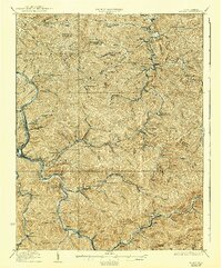
1928 Map of Logan
USGS Topo · Published 1940About this map
The Guyandot River and its labyrinthine tributaries define the landscape of Logan County as it appeared between the world wars. This terrain is deeply integrated with the Chesapeake and Ohio railroad network, which snakes through narrow valleys to serve isolated coal-country settlements and post offices. The map reveals the critical link between geography and early 20th-century industry, where towns like Rum Junction (Kleenkoal P.O.) and Five Block (Macneer P.O.) highlight the specific locations of company stores and postal hubs often lost to time.
Find a feature on this map
149 named features on this map. Tap any name to fly to it.
Don’t see what you’re looking for? This feature index may not catch every label — zoom into the map to look around manually.
Map Details
Editions of this 1928 Logan Map
3 editions found
Other maps of this area

1887 · Warfield
USGS Topo · 1:125,000

1891 · Oceana
USGS Topo · 1:125,000

1891 · Warfield
USGS Topo · 1:125,000

1892 · Huntington
USGS Topo · 1:125,000

1893 · Oceana
USGS Topo · 1:125,000

1898 · Huntington
USGS Topo · 1:125,000

1898 · Oceana
USGS Topo · 1:125,000

1899 · Charleston
USGS Topo · 1:125,000

1902 · Midkiff
USGS Topo · 1:62,500

1907 · Midkiff
USGS Topo · 1:62,500