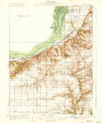
1937 Map of Lomax
USGS Topo · Published 1937About this map
Mississippi River islands and bars dominate the northwestern corner of this Illinois-Iowa borderland, where the Chicago Burlington and Quincy RR and the Atchison Topeka and Santa Fe RR converge near Lomax. The landscape is a study in early twentieth-century rural infrastructure, characterized by an exceptionally high density of country schools situated every few miles to serve the farming families of Durham and Rock Creek townships. Notable educational landmarks include the evocatively named Alma Mater Sch and Tiwappity Sch.
Find a feature on this map
73 named features on this map. Tap any name to fly to it.
Don’t see what you’re looking for? This feature index may not catch every label — zoom into the map to look around manually.
Map Details
Editions of this 1937 Lomax Map
2 editions found
Other maps of this area

1913 · Colchester
USGS Topo · 1:62,500

1918 · La Harpe
USGS Topo · 1:62,500

1932 · Lomax
USGS Topo · 1:62,500

1933 · Carthage
USGS Topo · 1:62,500

1934 · Oquawka
USGS Topo · 1:48,000

1934 · Burlington
USGS Topo · 1:48,000

1936 · Keokuk
USGS Topo · 1:62,500

1936 · Fort Madison
USGS Topo · 1:62,500

1937 · Carthage
USGS Topo · 1:62,500

1937 · Lomax
USGS Topo · 1:62,500