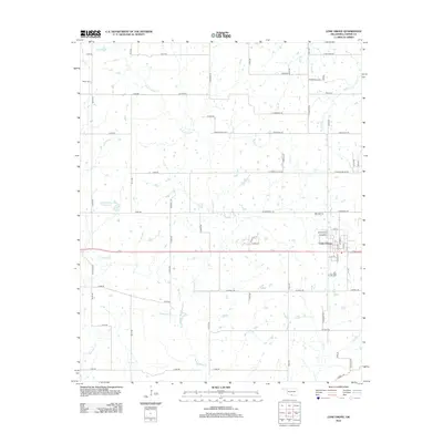
2012 Map of Lone Grove
USGS Topo · Published 2012About this map
Lone Grove serves as the central hub for this Carter County landscape, which is defined by a dense network of residential streets and rural routes that expand outward from the community core. To the west, the Upper Bayou Site 6 Reservoir is a prominent hydrological feature, while the surrounding territory is intricately drained by numerous waterways including Cottonwood Cr and Walnut Bayou. Genealogists may note the Keller Cem located in the northwestern quadrant along Bayou Rd. The map reveals a transition from the structured street grid of the town center to a more traditional rural section-line road system, featuring family-named thoroughfares such as Joe Kelley Rd, Anderson Rd, and Tipton Ln. The drainage patterns, particularly around Demijohn Cr and Bull Cr, suggest a terrain shaped by consistent water flow throughout the plains.
Find a feature on this map
71 named features on this map. Tap any name to fly to it.
Don’t see what you’re looking for? This feature index may not catch every label — zoom into the map to look around manually.
Map Details
Editions of this 2012 Lone Grove Map
This is the sole edition of this map. No revisions or reprints were ever made.
Other maps of this area

1901 · Ardmore
USGS Topo · 1:125,000

1918 · Ardmore
USGS Topo · 1:125,000

1957 · Ardmore
USGS Topo · 1:250,000

1963 · Ardmore
USGS Topo · 1:250,000

1964 · Ardmore West
USGS Topo · 1:24,000

1964 · Overbrook
USGS Topo · 1:24,000

1964 · Springer
USGS Topo · 1:24,000

1969 · Healdton
USGS Topo · 1:24,000

1969 · Lone Grove
USGS Topo · 1:24,000
1969 · Healdton SW
USGS Topo · 1:24,000