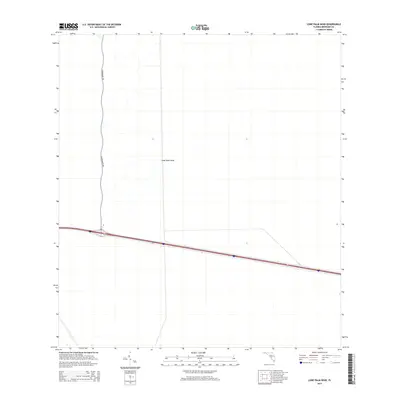
2015 Map of Lone Palm Head
USGS Topo · Published 2015About this map
Lone Palm Head anchors this interior landscape within the Florida Everglades, representing one of the distinct tree islands or hammocks that rise above the surrounding wetlands. This 2015 survey illustrates a sparsely developed section of western Broward County where human infrastructure is largely confined to the north-south corridor of Government Rd and a major east-west interstate highway that bisects the southern half of the map. The network of drainage canals and levees visible throughout the area reflects the long-term hydrological management of this ecosystem, contrasting the natural clustering of vegetation at the namesake head with the linear precision of modern engineering.
Find a feature on this map
2 named features on this map. Tap any name to fly to it.
Don’t see what you’re looking for? This feature index may not catch every label — zoom into the map to look around manually.
Map Details
Editions of this 2015 Lone Palm Head Map
This is the sole edition of this map. No revisions or reprints were ever made.
Other maps of this area

1956 · West Palm Beach
USGS Topo · 1:250,000

1957 · West Palm Beach
USGS Topo · 1:250,000

1958 · West Palm Beach
USGS Topo · 1:250,000

1973 · Everglades 4 NW
USGS Topo · 1:24,000
1973 · Everglades 4 SW
USGS Topo · 1:24,000

1973 · Everglades 3 NE
USGS Topo · 1:24,000

1974 · Everglades 1 SW
USGS Topo · 1:24,000

1974 · Everglades 2 SW
USGS Topo · 1:24,000

1974 · Everglades 2 SE
USGS Topo · 1:24,000
1974 · Everglades 3 SW
USGS Topo · 1:24,000