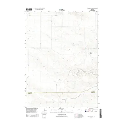
2014 Map of Lone Pine Butte
USGS Topo · Published 2014About this map
Lone Pine Butte rises as a prominent landmark in this high plains landscape on the border of the Nebraska Panhandle. The terrain is defined by the drainage of Lawrence Fork, which cuts across the northern half of the quadrangle, while Rocky Hollow carves through the southern section. These intermittent watercourses and the presence of Lone Pine Springs provided critical water sources for early ranching operations in this semi-arid environment. The survey captures the transition between Banner Co and Kimball Co, illustrating a rural landscape structured by a grid of section-line roads like Co Road 6 and Co Road 14. This geographic arrangement reflects the late 19th-century homesteading patterns that established the large-scale cattle ranching still characteristic of the region today.
Find a feature on this map
18 named features on this map. Tap any name to fly to it.
Don’t see what you’re looking for? This feature index may not catch every label — zoom into the map to look around manually.
Map Details
Editions of this 2014 Lone Pine Butte Map
This is the sole edition of this map. No revisions or reprints were ever made.
Other maps of this area

1898 · Scotts Bluff
USGS Topo · 1:125,000

1898 · Camp Clarke
USGS Topo · 1:125,000

1954 · Scottsbluff
USGS Topo · 1:250,000

1958 · Scottsbluff
USGS Topo · 1:250,000

1973 · Potter 2 SW
USGS Topo · 1:24,000

1973 · Scotts Bluff 4 SE
USGS Topo · 1:24,000

1973 · Kimball 1 SE
USGS Topo · 1:24,000

1973 · Scotts Bluff 4 SW
USGS Topo · 1:24,000

1973 · Kimball 1 NE
USGS Topo · 1:24,000

1973 · Kimball 1 NW
USGS Topo · 1:24,000