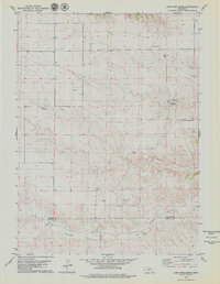
1979 Map of Lone Pine Butte
USGS Topo · Published 1979About this map
Lone Pine Butte serves as the focal point for this 1970s landscape on the high plains of the Nebraska Panhandle. The map documents an area defined by the convergence of ranching and energy extraction, centered on the boundary of Banner and Kimball counties. Scattered ranching operations, such as the Peterson Ranch and Mossberg Ranch, signify the established agricultural life of the region, while the prominent Oil Field and numerous Oil Wells across the northern and southern sectors point to the area's mid-century petroleum development. Topography is marked by the deep cut of Rocky Hollow in the south, providing a stark contrast to the tablelands where Lone Pine Springs remains a key water source. The presence of several Gravel Pits further emphasizes the extractive nature of the local economy during this era of rural Nebraska history.
Find a feature on this map
13 named features on this map. Tap any name to fly to it.
Don’t see what you’re looking for? This feature index may not catch every label — zoom into the map to look around manually.
Map Details
Editions of this 1979 Lone Pine Butte Map
This is the sole edition of this map. No revisions or reprints were ever made.
Other maps of this area

1898 · Scotts Bluff
USGS Topo · 1:125,000

1898 · Camp Clarke
USGS Topo · 1:125,000

1954 · Scottsbluff
USGS Topo · 1:250,000

1958 · Scottsbluff
USGS Topo · 1:250,000

1973 · Potter 2 SW
USGS Topo · 1:24,000

1973 · Scotts Bluff 4 SE
USGS Topo · 1:24,000

1973 · Kimball 1 SE
USGS Topo · 1:24,000

1973 · Scotts Bluff 4 SW
USGS Topo · 1:24,000

1973 · Kimball 1 NE
USGS Topo · 1:24,000

1973 · Kimball 1 NW
USGS Topo · 1:24,000