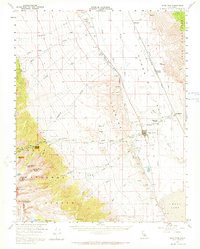
1958 Map of Lone Pine
USGS Topo · Published 1972About this map
Lone Pine sits at the dramatic meeting point of the Owens Valley floor and the steep eastern escarpment of the Sierra Nevada. This mid-century survey documents a landscape defined by the management of water and the reach of the Southern Pacific railroad, which served the small communities of Owenyo and Reward. The engineered path of the Los Angeles Aqueduct cuts along the base of the Alabama Hills, a region famously including Movie Flat, while to the north, the Manzanar area is noted alongside its local Manzanar Airport. High-altitude landmarks like Mount Whitney and Lone Pine Peak overlook the valley, where the Owens River flows toward the northern reaches of Owens Lake. The map details the transition from the valley floor to the wilderness of Inyo National Forest, tracing established routes like the Mt Whitney Trail and Whitney Portal Road.
Find a feature on this map
42 named features on this map. Tap any name to fly to it.
Don’t see what you’re looking for? This feature index may not catch every label — zoom into the map to look around manually.
Map Details
Editions of this 1958 Lone Pine Map
4 editions found
Other maps of this area

1905 · Olancha
USGS Topo · 1:125,000

1907 · Olancha
USGS Topo · 1:125,000

1907 · Mt. Whitney
USGS Topo · 1:125,000

1908 · Ballarat
USGS Topo · 1:250,000

1913 · Ballarat
USGS Topo · 1:250,000

1919 · Mt. Whitney
USGS Topo · 1:125,000

1937 · Mt. Whitney
USGS Topo · 1:125,000

1948 · Death Valley
USGS Topo · 1:250,000

1948 · Fresno
USGS Topo · 1:250,000

1950 · New York Butte
USGS Topo · 1:62,500