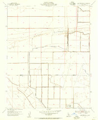
1954 Map of Lone Tree Well
USGS Topo · Published 1956About this map
Sand Ridge dominates the northern half of this mid-century survey, rising above an intricate network of water management features at the boundary of Kings and Kern counties. The Kern River Channel is channeled between levees, reflecting the era's heavy investment in land reclamation and agricultural irrigation. The Kings Co Kern Co line bisects the territory, which is marked by industrial and agricultural infrastructure including the Hacienda Spillway, the Homeland Canal, and a persistent Pipe Line. Small-scale evidence of habitation and local industry is anchored by Burhans Ranch and the eponymous Lone Tree Well near the southern margin. This survey, revised in 1954, documents the literal plumbing of the Central Valley landscape, where natural river courses were being systematically transformed into controlled channels and canals to support ranching and farming operations.
Find a feature on this map
12 named features on this map. Tap any name to fly to it.
Don’t see what you’re looking for? This feature index may not catch every label — zoom into the map to look around manually.
Map Details
Editions of this 1954 Lone Tree Well Map
2 editions found
Other maps of this area

1914 · Lost Hills
USGS Topo · 1:125,000

1929 · Hacienda Ranch
USGS Topo · 1:31,680

1929 · West Alpaugh
USGS Topo · 1:31,680

1930 · Miramonte Ranch
USGS Topo · 1:31,680

1931 · Harvester
USGS Topo · 1:31,680

1932 · Dudley Ridge
USGS Topo · 1:31,680

1932 · Antelope Plain
USGS Topo · 1:31,680

1932 · Reynolds Ranch
USGS Topo · 1:31,680

1932 · West Camp
USGS Topo · 1:31,680

1932 · Lone Tree Well
USGS Topo · 1:31,680