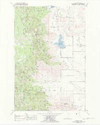
1989 Map of Lonepine
USGS Topo · Published 1989About this map
Lonepine serves as a small hub within the Flathead Indian Reservation Boundary in this late twentieth-century survey. The landscape is defined by the transition from the forested heights of the Lolo National Forest in the west to the irrigation-supported valley floor. The Camas Canal and its various branches weave across the eastern plains, feeding into the Dry Fork Reservoir and supporting local agriculture.
Find a feature on this map
18 named features on this map. Tap any name to fly to it.
Don’t see what you’re looking for? This feature index may not catch every label — zoom into the map to look around manually.
Map Details
Editions of this 1989 Lonepine Map
This is the sole edition of this map. No revisions or reprints were ever made.
Other maps of this area

1956 · Wallace
USGS Topo · 1:250,000

1960 · Wallace
USGS Topo · 1:250,000

1964 · Mill Pocket Creek
USGS Topo · 1:24,000

1964 · Markle Pass
USGS Topo · 1:24,000

1964 · Coney Peak
USGS Topo · 1:24,000

1964 · Baldy Lake
USGS Topo · 1:24,000

1964 · Lonepine
USGS Topo · 1:24,000

1964 · Hot Springs
USGS Topo · 1:24,000
1964 · Bassoo Peak
USGS Topo · 1:24,000
1964 · Niarada
USGS Topo · 1:24,000