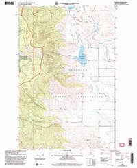
1999 Map of Lonepine
USGS Topo · Published 2003About this map
Lonepine stands as a focal point of this western Montana landscape, situated at the boundary of the Flathead Indian Reservation and just east of the Lolo National Forest boundary. The geography is defined by a series of water management and natural drainage systems, including the Dry Fork Reservoir and the Little Bitterroot River, which winds through the eastern portion of the quadrangle. Local civic life is anchored by the Community Hall and the Murray Memorial Cem, while the terrain rises sharply into Leitzen Gulch and terminates in distinctive landforms like Rattlesnake Butte. This late-century survey, based on imagery from the mid-1990s, documents the intersection of agricultural water infrastructure with public and tribal lands, including several Gravel Pits and various creek systems such as Garden Creek and Nancy Creek.
Find a feature on this map
16 named features on this map. Tap any name to fly to it.
Don’t see what you’re looking for? This feature index may not catch every label — zoom into the map to look around manually.
Map Details
Editions of this 1999 Lonepine Map
This is the sole edition of this map. No revisions or reprints were ever made.
Other maps of this area

1956 · Wallace
USGS Topo · 1:250,000

1960 · Wallace
USGS Topo · 1:250,000

1964 · Mill Pocket Creek
USGS Topo · 1:24,000

1964 · Markle Pass
USGS Topo · 1:24,000

1964 · Coney Peak
USGS Topo · 1:24,000

1964 · Baldy Lake
USGS Topo · 1:24,000

1964 · Lonepine
USGS Topo · 1:24,000

1964 · Hot Springs
USGS Topo · 1:24,000
1964 · Bassoo Peak
USGS Topo · 1:24,000
1964 · Niarada
USGS Topo · 1:24,000