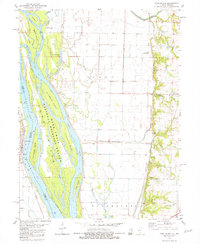
1981 Map of Long Island
USGS Topo · Published 1981About this map
The Mississippi River dominates this 1981 survey of the borderlands between Illinois and Missouri. The river’s complex network of side channels and islands includes Long Island, which is largely occupied by the National Mark Twain Wildlife Refuge. On the western bank, the Missouri settlement of La Grange sits at the river's edge, showing its historical orientation toward the water. The surrounding terrain is defined by low-lying wetlands and agricultural drainage, with features like the Rock and Ursa Creek Diversion Canal illustrating efforts to manage the landscape for farming. The eastern side of the river features a series of levees and narrow creek valleys, including Bear Creek and Ursa Creek, which feed into the main river channel.
Find a feature on this map
1 named feature on this map. Tap any name to fly to it.
Don’t see what you’re looking for? This feature index may not catch every label — zoom into the map to look around manually.
Map Details
Editions of this 1981 Long Island Map
This is the sole edition of this map. No revisions or reprints were ever made.
Other maps of this area

1903 · Kahoka
USGS Topo · 1:125,000

1903 · Palmyra
USGS Topo · 1:125,000

1925 · Quincy
USGS Topo · 1:62,500

1944 · Quincy
USGS Topo · 1:62,500

1945 · Quincy
USGS Topo · 1:62,500

1946 · Mendon
USGS Topo · 1:62,500

1948 · Quincy
USGS Topo · 1:250,000

1948 · Mendon
USGS Topo · 1:62,500

1949 · Maywood
USGS Topo · 1:24,000
1950 · Maywood
USGS Topo · 1:24,000