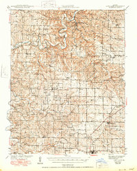
1942 Map of Long Lane
USGS Topo · Published 1950About this map
Bennett Spring State Park serves as a centerpiece for this Ozark landscape, where the cold waters of Bennett Springs feed into the Niangua River. The 1942 edition reflects a rural society structured around local civic nodes, with a remarkable density of one-room schoolhouses such as London Smoke Sch, Independence Sch, and Cudd Sch serving the surrounding family farms. The southeastern corner of the map shows the influence of industrial transport, where the St Louis San Francisco railroad passes through the settlements of Phillipsburg and Conway. A deep network of creek-side roads and hollows, including Spring Hollow and Woodward Hollow, connects scattered landmarks like Limekiln Ford and Lone Rock Ch, providing a detailed look at the township divisions of Jasper, Wilson, and Washington as they stood before mid-century modernization.
Find a feature on this map
75 named features on this map. Tap any name to fly to it.
Don’t see what you’re looking for? This feature index may not catch every label — zoom into the map to look around manually.
Map Details
Editions of this 1942 Long Lane Map
3 editions found

Other maps of this area

1884 · Springfield
USGS Topo · 1:125,000

1884 · Bolivar
USGS Topo · 1:125,000

1886 · Springfield
USGS Topo · 1:125,000

1892 · Bolivar
USGS Topo · 1:125,000

1933 · Stoutland
USGS Topo · 1:62,500

1934 · Macks Creek
USGS Topo · 1:48,000

1938 · Stoutland
USGS Topo · 1:62,500

1939 · Macks Creek
USGS Topo · 1:62,500

1939 · Long Lane
USGS Topo · 1:62,500

1941 · Lebanon
USGS Topo · 1:62,500