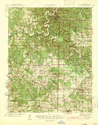
1942 Map of Long Lane
USGS Topo · Published 1942About this map
Bennett Spring State Park serves as a prominent focal point in this 1942 survey of the Ozark borderlands, where the Niangua River carves a deeply meandering path through the central landscape. The settlement of Long Lane occupies a central position along the high ground, while the southern margin is defined by the St Louis - San Francisco railroad corridor passing through Conway and Philipsburg. This era reflects a densely populated rural landscape characterized by a high frequency of one-room schoolhouses and community churches, including uniquely named sites like London Smoke Sch and Lonesome Hill Sch. The abundance of river crossings, such as Hackler Ford, and family-named cemeteries like Williams Cem and Shanks Cem indicate a society still deeply connected to localized creek-valley economies and traditional transit routes before modern highway consolidation.
Find a feature on this map
68 named features on this map. Tap any name to fly to it.
Don’t see what you’re looking for? This feature index may not catch every label — zoom into the map to look around manually.
Map Details
Editions of this 1942 Long Lane Map
3 editions found

Other maps of this area

1884 · Springfield
USGS Topo · 1:125,000

1884 · Bolivar
USGS Topo · 1:125,000

1886 · Springfield
USGS Topo · 1:125,000

1892 · Bolivar
USGS Topo · 1:125,000

1933 · Stoutland
USGS Topo · 1:62,500

1934 · Macks Creek
USGS Topo · 1:48,000

1938 · Stoutland
USGS Topo · 1:62,500

1939 · Macks Creek
USGS Topo · 1:62,500

1939 · Long Lane
USGS Topo · 1:62,500

1941 · Lebanon
USGS Topo · 1:62,500