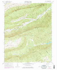
1965 Map of Long Spur
USGS Topo · Published 1978About this map
Walker Mountain and Little Walker Mountain dominate this mid-century topographic survey, where the deep drainages of the Jefferson National Forest meet the rural reaches of Wythe, Bland, and Pulaski counties. The settlement of Long Spur serves as a focal point along the narrow valley floor, supported by community institutions like Spur Branch Sch and Davis Ch. The map illustrates a landscape defined by sharp ridges and deep hollows, such as Panther Lick Hollow and Bearwallow Hollow, which constrained early development to the creek beds. To the south, the Gatewood Reservoir marks a significant hydrological feature, while the presence of the Appalachian Trail and a Lookout Tower atop the peaks highlights the region's transition into a managed recreational and forest resource area. The Norfolk and Western railway corridor and the small stop at Gunton Park reveal the vital transport links connecting these isolated highlands.
Find a feature on this map
47 named features on this map. Tap any name to fly to it.
Don’t see what you’re looking for? This feature index may not catch every label — zoom into the map to look around manually.
Map Details
Editions of this 1965 Long Spur Map
Other maps of this area

1887 · Pocahontas
USGS Topo · 1:125,000

1889 · Hillsville
USGS Topo · 1:125,000

1889 · Wytheville
USGS Topo · 1:125,000

1890 · Dublin
USGS Topo · 1:125,000

1891 · Pocahontas
USGS Topo · 1:125,000

1891 · Dublin
USGS Topo · 1:125,000

1892 · Hillsville
USGS Topo · 1:125,000

1892 · Wytheville
USGS Topo · 1:125,000

1894 · Pocahontas
USGS Topo · 1:125,000

1895 · Pocahontas
USGS Topo · 1:125,000