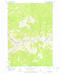
1962 Map of Long Tom Mtn
USGS Topo · Published 1976About this map
Salmon River and the Middle Fork Salmon River converge in this 1962 field-checked study of the Salmon National Forest. The landscape is defined by its verticality and river-centric utility, featuring backcountry landmarks such as Horse Heaven Lookout and the Airstrip near Ebenezer Bar. This survey provides clear documentation of river miles, marking Mile 197 through Mile 204, alongside cultural sites like the Indian Petroglyphs on the northern bank. Infrastructure is sparse but vital, represented by the Stoddard Bridge and primitive routes like the Bear Basin Trail (Jeep). From the high point of Long Tom Mountain to the depths of the river canyon, the map records the region's character as a managed wilderness prior to modern developments.
Find a feature on this map
38 named features on this map. Tap any name to fly to it.
Don’t see what you’re looking for? This feature index may not catch every label — zoom into the map to look around manually.
Map Details
Editions of this 1962 Long Tom Mtn Map
3 editions found
Other maps of this area

1950 · Blackbird Mtn
USGS Topo · 1:62,500

1951 · Blackbird Mtn
USGS Topo · 1:62,500

1956 · Elk City
USGS Topo · 1:250,000

1960 · Elk City
USGS Topo · 1:250,000

1960 · Shoup
USGS Topo · 1:62,500

1962 · Square Top
USGS Topo · 1:24,000

1962 · Long Tom Mtn
USGS Topo · 1:24,000

1962 · Aggipah Mtn
USGS Topo · 1:24,000

1962 · Mt Mc Guire
USGS Topo · 1:24,000

1962 · Horse Creek Butte
USGS Topo · 1:24,000