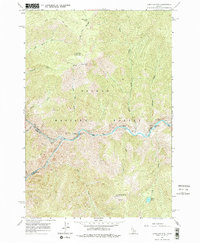
1962 Map of Long Tom Mtn
USGS Topo · Published 1976About this map
Salmon River waters and the Middle Fork Salmon River define this wilderness corridor along the Lemhi and Idaho County border. Surveyed in the early 1960s, the map reveals a landscape accessed primarily by water or rugged tracks like the Bear Basin Trail (Jeep) and Stoddard Trail. Local cultural history is marked by Indian Petroglyphs near the mouth of Colson Creek and the remote Airstrip at Ebenezer Bar. Higher elevations reach toward Long Tom Mountain and Horse Heaven, where lookouts once monitored the timber of the Salmon National Forest. This document captures the primitive recreation and transport infrastructure of the era, from the Stoddard Bridge to the dangerous navigation at Long Tom Rapids.
Find a feature on this map
35 named features on this map. Tap any name to fly to it.
Don’t see what you’re looking for? This feature index may not catch every label — zoom into the map to look around manually.
Map Details
Editions of this 1962 Long Tom Mtn Map
3 editions found
Other maps of this area

1950 · Blackbird Mtn
USGS Topo · 1:62,500

1951 · Blackbird Mtn
USGS Topo · 1:62,500

1956 · Elk City
USGS Topo · 1:250,000

1960 · Elk City
USGS Topo · 1:250,000

1960 · Shoup
USGS Topo · 1:62,500

1962 · Square Top
USGS Topo · 1:24,000

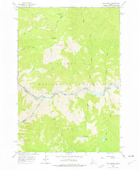
1962 · Long Tom Mtn
USGS Topo · 1:24,000

1962 · Aggipah Mtn
USGS Topo · 1:24,000

1962 · Mt Mc Guire
USGS Topo · 1:24,000

1962 · Horse Creek Butte
USGS Topo · 1:24,000