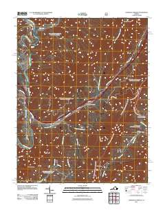
2011 Map of Longdale Furnace
USGS Topo · Published 2011About this map
Longdale Furnace serves as a central anchor for this Alleghany County landscape, where transportation corridors and industrial history intersect. The Cowpasture River winds through the western reaches, passing the settlement of Nicelytown and the narrow passage at Colemans Tunnel. This 2011 survey captures the modern alignment of Interstate 64 as it follows the valley carved by Simpson Creek, bridging the gap between Brushy Mountain and Anthony Knobs.
Find a feature on this map
31 named features on this map. Tap any name to fly to it.
Don’t see what you’re looking for? This feature index may not catch every label — zoom into the map to look around manually.
Map Details
Editions of this 2011 Longdale Furnace Map
This is the sole edition of this map. No revisions or reprints were ever made.
Other maps of this area

1894 · Natural Bridge
USGS Topo · 1:125,000

1894 · Natural Bridge
USGS Topo · 1:62,500

1907 · Natural Bridge Special
USGS Topo · 1:62,500

1913 · Eagle Rock
USGS Topo · 1:48,000

1915 · Eagle Rock
USGS Topo · 1:62,500

1931 · Healing Springs
USGS Topo · 1:24,000

1933 · Healing Springs
USGS Topo · 1:31,680

1945 · Clifton Forge
USGS Topo · 1:62,500

1946 · Millboro
USGS Topo · 1:62,500

1947 · Roanoke
USGS Topo · 1:250,000