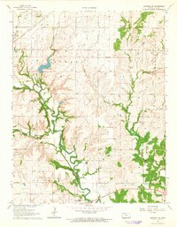
1964 Map of Longton NW
USGS Topo · Published 1965About this map
The Elk River carves a winding path through the center of this Elk County landscape, where the town of Elk Falls sits at the southern edge of the survey. This 1964 record illustrates a region defined by its water and historical borders, most notably the Old Indian Treaty Boundary that cuts horizontally across the terrain. To the northwest, the Atchison Topeka and Santa Fe railroad skirts the banks of Snake Creek, while Polk Daniels Lake provides a centralized recreational focus with its designated Picnic Area and Spillway. The map provides specific locations for local industry and heritage, including several Oil Wells, a Quarry, and a local Cem near the riverbanks. The intricate drainage systems of Hitchen Creek and its many branches emphasize the dissected nature of the prairie upland as it meets the river valley.
Find a feature on this map
23 named features on this map. Tap any name to fly to it.
Don’t see what you’re looking for? This feature index may not catch every label — zoom into the map to look around manually.
Map Details
Editions of this 1964 Longton NW Map
2 editions found
Other maps of this area

1885 · Eureka
USGS Topo · 1:125,000

1885 · Sedan
USGS Topo · 1:125,000

1888 · Eureka
USGS Topo · 1:125,000

1889 · Sedan
USGS Topo · 1:125,000

1894 · Eureka
USGS Topo · 1:125,000

1939 · Severy
USGS Topo · 1:62,500

1941 · Severy
USGS Topo · 1:62,500

1955 · Wichita
USGS Topo · 1:250,000

1958 · Wichita
USGS Topo · 1:250,000
1962 · Oak Valley
USGS Topo · 1:24,000