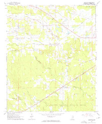
1965 Map of Longview
USGS Topo · Published 1976About this map
The community of Longview serves as a central hub in this mid-1960s survey of Oktibbeha County, situated along the Illinois Central railroad line. The landscape is defined by an intricate network of waterways, including the winding Trim Cane Creek and the curiously named Talking Warrior Creek. To the north, the small settlement of Adaton sits near a Roadside Park, while the southern portion of the map transitions into the protected lands of the Noxubee National Wildlife Refuge.
Find a feature on this map
22 named features on this map. Tap any name to fly to it.
Don’t see what you’re looking for? This feature index may not catch every label — zoom into the map to look around manually.
Map Details
Editions of this 1965 Longview Map
3 editions found
Other maps of this area

1953 · West Point
USGS Topo · 1:250,000

1958 · West Point
USGS Topo · 1:250,000

1959 · Pheba
USGS Topo · 1:62,500

1963 · West Point
USGS Topo · 1:250,000

1965 · Starkville
USGS Topo · 1:24,000

1965 · Bluff Lake
USGS Topo · 1:24,000

1965 · Longview
USGS Topo · 1:24,000

1965 · Bradley
USGS Topo · 1:24,000

1972 · Maben
USGS Topo · 1:24,000

1972 · Double Springs
USGS Topo · 1:24,000