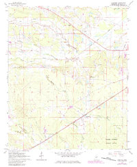
1965 Map of Longview
USGS Topo · Published 1982About this map
The Illinois Central Gulf railroad cuts a straight line through the center of this Mississippi landscape, connecting the small community of Longview to the surrounding timber and farmland of Oktibbeha County. This mid-century survey reveals a rural network of country roads and family-named landmarks, such as Self and Adaton, interspersed with a high density of rural houses of worship including Bethel Ch, Union Hill Ch, and New Hope Ch.
Find a feature on this map
24 named features on this map. Tap any name to fly to it.
Don’t see what you’re looking for? This feature index may not catch every label — zoom into the map to look around manually.
Map Details
Editions of this 1965 Longview Map
3 editions found
Other maps of this area

1953 · West Point
USGS Topo · 1:250,000

1958 · West Point
USGS Topo · 1:250,000

1959 · Pheba
USGS Topo · 1:62,500

1963 · West Point
USGS Topo · 1:250,000

1965 · Starkville
USGS Topo · 1:24,000

1965 · Bluff Lake
USGS Topo · 1:24,000

1965 · Longview
USGS Topo · 1:24,000

1965 · Bradley
USGS Topo · 1:24,000

1972 · Maben
USGS Topo · 1:24,000

1972 · Double Springs
USGS Topo · 1:24,000