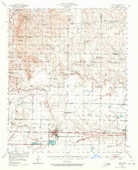
1950 Map of Lonoke
USGS Topo · Published 1972About this map
Lonoke serves as the central hub of this mid-century central Arkansas landscape, where the Chicago Rock Island and Pacific railroad forms a straight east-west corridor through the prairie. The map documents a rural transition as several schools are noted as out of use, including Union Grove Sch (Abandoned) and Brownsville Sch (Abandoned), hinting at the consolidation of rural districts during this era. Genealogists will find a wealth of burial sites such as the Camp Nelson Confederate Cem and Hicks Cem, alongside small community centers like Sylvania and Butlerville. Water management and land use are evident in the sprawling State Fish Hatchery south of the main township and the winding courses of Wattensaw Bayou and Two Prairie Bayou that drain the agricultural flats of Hickory Plain.
Find a feature on this map
80 named features on this map. Tap any name to fly to it.
Don’t see what you’re looking for? This feature index may not catch every label — zoom into the map to look around manually.
Map Details
Editions of this 1950 Lonoke Map
2 editions found

Other maps of this area

1891 · Little Rock
USGS Topo · 1:125,000

1893 · Little Rock
USGS Topo · 1:125,000

1932 · Kensett
USGS Topo · 1:62,500

1935 · Kensett
USGS Topo · 1:62,500

1935 · Hazen
USGS Topo · 1:62,500

1937 · Stuttgart
USGS Topo · 1:62,500

1937 · England
USGS Topo · 1:48,000

1939 · Stuttgart
USGS Topo · 1:62,500

1940 · Lonoke
USGS Topo · 1:62,500

1941 · Hazen
USGS Topo · 1:62,500