
1965 Map of Lookout Butte
USGS Topo · Published 1967About this map
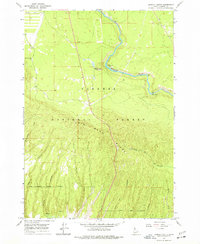
Henrys Fork winds through the heart of this mid-1960s survey, carving a path through the northeastern corner of the Targhee National Forest. The landscape is defined by the massive elevation changes of Big Bend Ridge, which dominates the southern half of the quadrangle with its network of deep drainages. Several of these canyons, such as Anderson Mill Canyon and Jump Off Canyon, suggest the historical timber or transit routes that once utilized the natural breaks in the ridge.
Find a feature on this map
19 named features on this map. Tap any name to fly to it.
Don’t see what you’re looking for? This feature index may not catch every label — zoom into the map to look around manually.
Map Details
Editions of this 1965 Lookout Butte Map
2 editions found
Other maps of this area

1955 · Ashton
USGS Topo · 1:250,000

1958 · Ashton
USGS Topo · 1:250,000

1960 · Ashton
USGS Topo · 1:250,000

1964 · Hatchery Butte
USGS Topo · 1:24,000

1964 · Last Chance
USGS Topo · 1:24,000

1965 · Lemon Lake
USGS Topo · 1:24,000

1965 · Ashton
USGS Topo · 1:24,000

1965 · Snake River Butte
USGS Topo · 1:24,000

1965 · Blue Creek Reservoir
USGS Topo · 1:24,000
1965 · Warm River
USGS Topo · 1:24,000