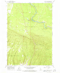
1965 Map of Lookout Butte
USGS Topo · Published 1977About this map
Henrys Fork snakes through the northern reach of this landscape, a prominent waterway that historically served as a vital corridor in the high country. Situated within the Targhee National Forest, the terrain is defined by the massive basalt and rhyolite formations of Big Bend Ridge, which separates the river valley from the rugged drainage systems to the south. The 1965 field check documents specific historical landmarks like Hatchery Ford (Site) and the drop of Sheep Falls. To the south, the map reveals a complex network of named ravines including Anderson Mill Canyon, Jump Off Canyon, and Kerr Canyon. This area, marked by Lookout Butte, shows the intersection of natural water sources like Putney Springs and Rattlesnake Creek with the high-elevation forest and rangeland typical of the Idaho-Wyoming border region.
Find a feature on this map
17 named features on this map. Tap any name to fly to it.
Don’t see what you’re looking for? This feature index may not catch every label — zoom into the map to look around manually.
Map Details
Editions of this 1965 Lookout Butte Map
2 editions found
Other maps of this area

1955 · Ashton
USGS Topo · 1:250,000

1958 · Ashton
USGS Topo · 1:250,000

1960 · Ashton
USGS Topo · 1:250,000

1964 · Hatchery Butte
USGS Topo · 1:24,000

1964 · Last Chance
USGS Topo · 1:24,000

1965 · Lemon Lake
USGS Topo · 1:24,000

1965 · Ashton
USGS Topo · 1:24,000

1965 · Lookout Butte
USGS Topo · 1:24,000

1965 · Snake River Butte
USGS Topo · 1:24,000

1965 · Blue Creek Reservoir
USGS Topo · 1:24,000