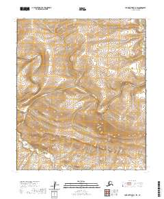
2020 Map of Lookout Ridge A-1 SW
USGS Topo · Published 2020About this map
Awuna River meanders across this Arctic landscape, carving a wide valley through the North Slope terrain. The river system, which includes the confluence with Lookout River in the southwestern quadrant, dominates the hydrology of this remote region. This 2020 survey illustrates the complex drainage patterns and elevation shifts typical of the area south of the Arctic coast. The map is organized by the Public Land Survey System, specifically defining boundaries for t4s r19w and t5s r19w, which aid in locating specific plots in a region devoid of permanent road infrastructure or established settlements. The landforms captured here represent the natural state of the Alaskan interior, where watercourses like the Awuna River dictate the topography.
Find a feature on this map
6 named features on this map. Tap any name to fly to it.
Don’t see what you’re looking for? This feature index may not catch every label — zoom into the map to look around manually.
Map Details
Editions of this 2020 Lookout Ridge A-1 SW Map
This is the sole edition of this map. No revisions or reprints were ever made.
Other maps of this area

1951 · Lookout Ridge
USGS Topo · 1:250,000

1951 · Howard Pass
USGS Topo · 1:250,000

1956 · Lookout Ridge
USGS Topo · 1:250,000

1956 · Howard Pass
USGS Topo · 1:250,000

1984 · Howard Pass D-1
USGS Topo · 1:63,360
1984 · Howard Pass D-2
USGS Topo · 1:63,360
1984 · Lookout Ridge A-1
USGS Topo · 1:63,360
1984 · Lookout Ridge A-2
USGS Topo · 1:63,360
2016 · Howard Pass D-2 NE
USGS Topo · 1:25,000
2016 · Howard Pass D-1 NW
USGS Topo · 1:25,000