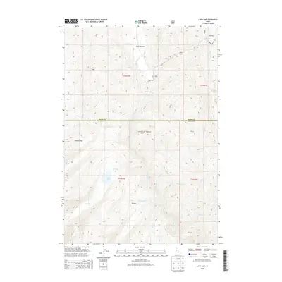
2013 Map of Loon Lake
USGS Topo · Published 2013About this map
Secesh River and its many tributaries, including Whangdoodle Cr and Grimmet Cr, define the drainage patterns through the high elevations of the Payette National Forest. This 2013 topographic study highlights the importance of the Warren Wagon Rd as the primary artery through the remote wilderness of Central Idaho, crossing the boundary between Idaho Co and Valley Co. Large meadow systems such as Secesh Meadows and Stratton Meadow provide distinct breaks in the forest cover, while Loon Lake and the Chinook Campground serve as significant recreational landmarks for those navigating the backcountry. The map also records early land divisions through numerous Private Boundaries, such as PB 40 and PB 38, which contrast with the surrounding public forest lands.
Find a feature on this map
34 named features on this map. Tap any name to fly to it.
Don’t see what you’re looking for? This feature index may not catch every label — zoom into the map to look around manually.
Map Details
Editions of this 2013 Loon Lake Map
This is the sole edition of this map. No revisions or reprints were ever made.
Other maps of this area

1956 · Burgdorf
USGS Topo · 1:62,500

1956 · Warren
USGS Topo · 1:62,500

1956 · Elk City
USGS Topo · 1:250,000

1960 · Elk City
USGS Topo · 1:250,000

1969 · Loon Lake
USGS Topo · 1:24,000

1969 · Pony Meadows
USGS Topo · 1:24,000

1969 · Enos Lake
USGS Topo · 1:24,000
1969 · Box Lake
USGS Topo · 1:24,000

1969 · Williams Peak
USGS Topo · 1:24,000
1969 · Victor Peak
USGS Topo · 1:24,000