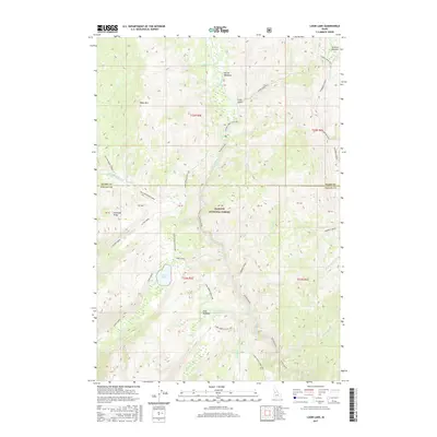
2017 Map of Loon Lake
USGS Topo · Published 2017About this map
Payette National Forest encompasses this high-elevation backcountry where the border of Idaho and Valley counties bisects the terrain. The landscape is defined by the drainage systems of the Secesh River and Loon Creek, which feed into the prominent Loon Lake. This 2017 survey details a network of canyons and ridges, most notably Ruby Mountain and Diamond Ridge. Historically significant travel routes like the Warren Wagon Rd wind through the north, providing access to remote locations such as Secesh Meadows and Stratton Meadow. The mapping of small tributaries like Whangdoodle Creek and Jungle Creek illustrates the complex hydrology of this wilderness area. For researchers, the inclusion of specific land parcels such as PB 41 and PB 42 offers a look at surveyed boundaries within the protected forest lands.
Find a feature on this map
40 named features on this map. Tap any name to fly to it.
Don’t see what you’re looking for? This feature index may not catch every label — zoom into the map to look around manually.
Map Details
Editions of this 2017 Loon Lake Map
This is the sole edition of this map. No revisions or reprints were ever made.
Other maps of this area

1956 · Burgdorf
USGS Topo · 1:62,500

1956 · Warren
USGS Topo · 1:62,500

1956 · Elk City
USGS Topo · 1:250,000

1960 · Elk City
USGS Topo · 1:250,000

1969 · Loon Lake
USGS Topo · 1:24,000

1969 · Pony Meadows
USGS Topo · 1:24,000

1969 · Enos Lake
USGS Topo · 1:24,000
1969 · Box Lake
USGS Topo · 1:24,000

1969 · Williams Peak
USGS Topo · 1:24,000
1969 · Victor Peak
USGS Topo · 1:24,000