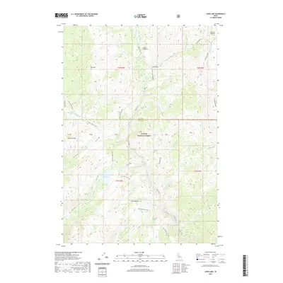
2020 Map of Loon Lake
USGS Topo · Published 2020About this map
Payette National Forest dominates this Idaho landscape, where the Secesh River and its many tributaries carve through high-elevation terrain. This 2020 survey documents a wilderness characterized by distinct meadows and ridge lines, including Secesh Meadows to the north and Enos Meadow further south. The hydrography is particularly complex, defined by the prominent Loon Lake and a web of drainages such as Willow Basket Creek, Victor Creek, and Grimmet Creek. Local travel is largely restricted to back-country routes like the Warren Wagon Rd and National Forest Road 080. The map also preserves the nomenclature of several peaks and ridges, including Ruby Mtn, Steamboat Ridge, and Diamond Ridge, marking their positions relative to the Idaho Co and Valley Co border.
Find a feature on this map
40 named features on this map. Tap any name to fly to it.
Don’t see what you’re looking for? This feature index may not catch every label — zoom into the map to look around manually.
Map Details
Editions of this 2020 Loon Lake Map
This is the sole edition of this map. No revisions or reprints were ever made.
Other maps of this area

1956 · Burgdorf
USGS Topo · 1:62,500

1956 · Warren
USGS Topo · 1:62,500

1956 · Elk City
USGS Topo · 1:250,000

1960 · Elk City
USGS Topo · 1:250,000

1969 · Loon Lake
USGS Topo · 1:24,000

1969 · Pony Meadows
USGS Topo · 1:24,000

1969 · Enos Lake
USGS Topo · 1:24,000
1969 · Box Lake
USGS Topo · 1:24,000

1969 · Williams Peak
USGS Topo · 1:24,000
1969 · Victor Peak
USGS Topo · 1:24,000