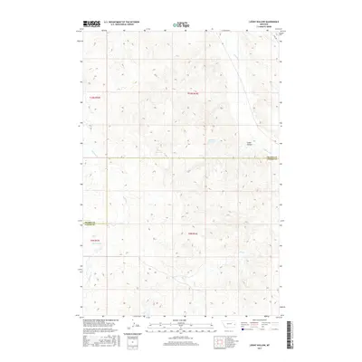
2017 Map of Loony Hollow
USGS Topo · Published 2017About this map
O'Fallon Cr winds through the northern reach of this Montana landscape, where the boundary between Prairie County and Custer County divides the terrain. The map centers on the distinctive namesake Loony Hollow, a landform defined by a complex network of seasonal drainages including Ash Cr, Dry Cr, and Whitney Cr. Evidence of rural water management is prominent in the upland sections, marked by features such as Horse Reservoir and Archdale Reservoir. In the southwest, the named settlement of Shoemaker stands as a focal point for local history research. The presence of Ismay Rd in the northeast corner provides the primary modern transport link across this drainage-rich territory, which remains dominated by the Township and Range survey system, including t10n r54e and t9n r53e.
Find a feature on this map
14 named features on this map. Tap any name to fly to it.
Don’t see what you’re looking for? This feature index may not catch every label — zoom into the map to look around manually.
Map Details
Editions of this 2017 Loony Hollow Map
This is the sole edition of this map. No revisions or reprints were ever made.
Other maps of this area

1953 · Miles City
USGS Topo · 1:250,000

1957 · Miles City
USGS Topo · 1:250,000

1958 · Miles City
USGS Topo · 1:250,000

1969 · Little Whitney Creek
USGS Topo · 1:24,000

1969 · Montague Butte
USGS Topo · 1:24,000

1969 · Flat Top Butte NE
USGS Topo · 1:24,000

1980 · Terry
USGS Topo · 1:100,000
1980 · Miles City
USGS Topo · 1:100,000

1981 · Baker
USGS Topo · 1:100,000

1981 · Mildred NE
USGS Topo · 1:24,000