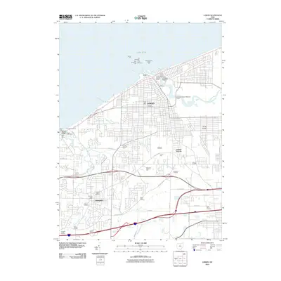
2010 Map of Lorain
USGS Topo · Published 2010About this map
Lake Erie dominates the northern horizon of this coastal survey, where the Black River meets the industrial and maritime hub of Lorain. The shoreline is heavily shaped by navigation infrastructure, including the East Breakwater Light Lorain Lighthouse and the Charles Berry Bascule Bridge which spans the river downtown. Further inland, the map captures the transition from urban centers to the residential and commercial corridors of Amherst and South Lorain.
Find a feature on this map
54 named features on this map. Tap any name to fly to it.
Don’t see what you’re looking for? This feature index may not catch every label — zoom into the map to look around manually.
Map Details
Editions of this 2010 Lorain Map
This is the sole edition of this map. No revisions or reprints were ever made.
Other maps of this area

1901 · Oberlin
USGS Topo · 1:62,500

1903 · Vermilion
USGS Topo · 1:62,500

1903 · Oberlin
USGS Topo · 1:62,500

1953 · Grafton
USGS Topo · 1:24,000

1953 · Avon
USGS Topo · 1:24,000

1956 · Toledo
USGS Topo · 1:250,000

1959 · Vermilion East
USGS Topo · 1:24,000

1959 · Kipton
USGS Topo · 1:24,000

1960 · Oberlin
USGS Topo · 1:24,000
1960 · Lorain
USGS Topo · 1:24,000