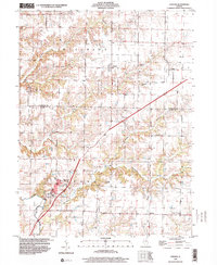
1998 Map of Loraine
USGS Topo · Published 2000About this map
Loraine stands as the primary hub in this late-century landscape, positioned where the Conrail line cuts through the townships of Keene and Houston. The terrain is defined by a dense network of drainage systems, including Bear Creek, Panther Creek, and Thurman Creek, which carve through the agricultural fields and small settlements of Adams and Hancock counties. This survey is particularly notable for its documentation of family and community history, preserving the locations of several small burial grounds such as Bean Cem, Breneman Cem, and the Old Loraine Cem. The agricultural and logistical character of the era is further evidenced by the presence of private aviation facilities like the Hemming Landing Strip and the Clear Landing Strip, alongside long-established rural community centers like the Centennial Ebenezer Ch and the small hamlet of Stillwell.
Find a feature on this map
30 named features on this map. Tap any name to fly to it.
Don’t see what you’re looking for? This feature index may not catch every label — zoom into the map to look around manually.
Map Details
Editions of this 1998 Loraine Map
This is the sole edition of this map. No revisions or reprints were ever made.
Other maps of this area

1933 · Carthage
USGS Topo · 1:62,500

1936 · Keokuk
USGS Topo · 1:62,500

1937 · Carthage
USGS Topo · 1:62,500

1946 · Mendon
USGS Topo · 1:62,500

1948 · Mendon
USGS Topo · 1:62,500

1948 · Camp Point
USGS Topo · 1:62,500

1950 · Keokuk
USGS Topo · 1:62,500

1958 · Burlington
USGS Topo · 1:250,000

1961 · Burlington
USGS Topo · 1:250,000

1963 · Burlington
USGS Topo · 1:250,000