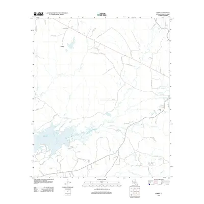
2012 Map of Loring
USGS Topo · Published 2012About this map
The Zwolle Oil Field dominates the northern reaches of this Sabine Parish landscape, reflecting the long-standing petroleum heritage of western Louisiana. Centered on the settlement of Loring, the terrain is defined by the expansive waters of the Toledo Bend Reservoir and its numerous finger-like tributaries, including Bayou La Nana and Negreet Cr. This 2012 survey illustrates a landscape where energy extraction and water resources converge, shaped by a network of local roads such as Sibley Rd and Mount Olive Rd. Genealogists and local historians can locate several rural burial sites that anchor the community's history, including Fenders Cem, Randolph Cem, and Pilgrim Rest Cem. The intricate shoreline of the reservoir highlights the significant geographic shift in the region following the damming of the Sabine River, creating a complex interface of land and water across the central and southern portions of the map.
Find a feature on this map
82 named features on this map. Tap any name to fly to it.
Don’t see what you’re looking for? This feature index may not catch every label — zoom into the map to look around manually.
Map Details
Editions of this 2012 Loring Map
This is the sole edition of this map. No revisions or reprints were ever made.
Other maps of this area

1941 · Zwolle
USGS Topo · 1:62,500

1942 · Many
USGS Topo · 1:62,500

1942 · Florien
USGS Topo · 1:62,500

1943 · Many
USGS Topo · 1:62,500

1944 · Negreet
USGS Topo · 1:62,500

1944 · Florien
USGS Topo · 1:62,500

1944 · Zwolle
USGS Topo · 1:62,500

1953 · Alexandria
USGS Topo · 1:250,000

1954 · Florien
USGS Topo · 1:62,500
1954 · Florien
USGS Topo · 1:24,000