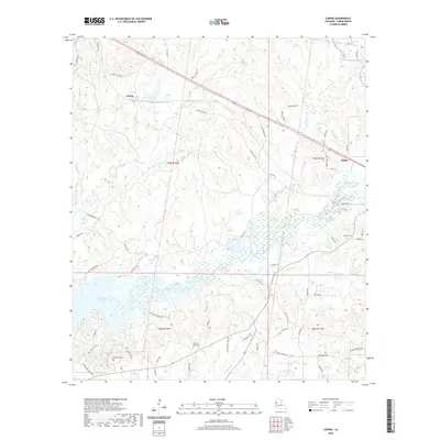
2020 Map of Loring
USGS Topo · Published 2020About this map
The settlement of Loring and the western outskirts of Many anchor this portion of Sabine Parish, where the local economy and geography are defined by the expansive Toledo Bend Reservoir. The landscape is etched by a dense network of waterways, including Bayou La Nana, Hurricane Cr, and Edmondson Cr, which weave through a terrain heavily marked by industrial infrastructure like the Sabine Landfill Rd and the Patterson Oil Field Rd. This modern survey illustrates the persistent rural character of the region, where family history is preserved in several scattered burial grounds. Researchers will find Anderson Cem and Pilgrim Rest Cem positioned among the timbered hills and drainages, while Fenders Cem sits near the eastern edge of the quadrangle. The map captures the interface between the parish's rolling topography and the massive reservoir that reshaped its western border.
Find a feature on this map
64 named features on this map. Tap any name to fly to it.
Don’t see what you’re looking for? This feature index may not catch every label — zoom into the map to look around manually.
Map Details
Editions of this 2020 Loring Map
This is the sole edition of this map. No revisions or reprints were ever made.
Other maps of this area

1941 · Zwolle
USGS Topo · 1:62,500

1942 · Many
USGS Topo · 1:62,500

1942 · Florien
USGS Topo · 1:62,500

1943 · Many
USGS Topo · 1:62,500

1944 · Negreet
USGS Topo · 1:62,500

1944 · Florien
USGS Topo · 1:62,500

1944 · Zwolle
USGS Topo · 1:62,500

1953 · Alexandria
USGS Topo · 1:250,000

1954 · Florien
USGS Topo · 1:62,500
1954 · Florien
USGS Topo · 1:24,000