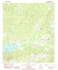
1988 Map of Loring
USGS Topo · Published 1988About this map
The Toledo Bend Reservoir dominates the southwestern portion of this Sabine Parish landscape, reflecting the significant hydrological changes in the region by the late 1980s. This survey, compiled from 1982 aerial photography, captures the inundated river valleys and the intricate shoreline where Prairie Creek and Hurricane Creek meet the reservoir. The small settlement of Loring remains a focal point in the northwest, situated near Loring Lake and a prominent Radio Tower.
Find a feature on this map
18 named features on this map. Tap any name to fly to it.
Don’t see what you’re looking for? This feature index may not catch every label — zoom into the map to look around manually.
Map Details
Editions of this 1988 Loring Map
This is the sole edition of this map. No revisions or reprints were ever made.
Other maps of this area

1941 · Zwolle
USGS Topo · 1:62,500

1942 · Many
USGS Topo · 1:62,500

1942 · Florien
USGS Topo · 1:62,500

1943 · Many
USGS Topo · 1:62,500

1944 · Negreet
USGS Topo · 1:62,500

1944 · Florien
USGS Topo · 1:62,500

1944 · Zwolle
USGS Topo · 1:62,500

1953 · Alexandria
USGS Topo · 1:250,000

1954 · Florien
USGS Topo · 1:62,500
1954 · Florien
USGS Topo · 1:24,000