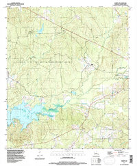
1994 Map of Loring
USGS Topo · Published 1996About this map
Toledo Bend Reservoir dominates the southwestern portion of this landscape, its complex shoreline and submerged inlets creating a stark contrast with the upland piney woods. This area of Sabine Parish is defined by the managed conservation lands of the Sabine State Wildlife Management Area, where a network of watercourses including Hurricane Creek and Choctaw Creek feed into the reservoir system. The map documents small, dispersed settlements like Loring, Edmondson, and Moore, which are interconnected by a web of light-duty roads and pipelines.
Find a feature on this map
19 named features on this map. Tap any name to fly to it.
Don’t see what you’re looking for? This feature index may not catch every label — zoom into the map to look around manually.
Map Details
Editions of this 1994 Loring Map
This is the sole edition of this map. No revisions or reprints were ever made.
Other maps of this area

1941 · Zwolle
USGS Topo · 1:62,500

1942 · Many
USGS Topo · 1:62,500

1942 · Florien
USGS Topo · 1:62,500

1943 · Many
USGS Topo · 1:62,500

1944 · Negreet
USGS Topo · 1:62,500

1944 · Florien
USGS Topo · 1:62,500

1944 · Zwolle
USGS Topo · 1:62,500

1953 · Alexandria
USGS Topo · 1:250,000

1954 · Florien
USGS Topo · 1:62,500
1954 · Florien
USGS Topo · 1:24,000