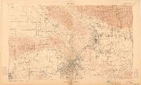
1900 Map of Los Angeles
USGS Topo · Published 1904About this map
Los Angeles River flows through a landscape defined by expansive Spanish land grants and a rapidly growing rail network at the close of the 19th century. Large ranchos like Ex Mission San Fernando, Rodeo de Las Aguas, and La Brea still dominate the cadastral map, framing emerging hubs like Hollywood and Burbank. To the north, the San Gabriel Timber Land Reserve rises toward San Gabriel Peak and Mt. Wilson, while the valley floor is crisscrossed by the Southern Pacific R. R. and the Atchison Topeka and Santa Fe R. R.
Find a feature on this map
154 named features on this map. Tap any name to fly to it.
Don’t see what you’re looking for? This feature index may not catch every label — zoom into the map to look around manually.
Map Details
Editions of this 1900 Los Angeles Map
4 editions found

Other maps of this area

1894 · Los Angeles
USGS Topo · 1:62,500

1894 · Pomona
USGS Topo · 1:62,500

1896 · Pasadena
USGS Topo · 1:62,500

1896 · Anaheim
USGS Topo · 1:62,500

1896 · Redondo
USGS Topo · 1:62,500

1896 · Santa Monica
USGS Topo · 1:62,500

1896 · Downey
USGS Topo · 1:62,500

1897 · Pomona
USGS Topo · 1:62,500

1898 · Pomona
USGS Topo · 1:62,500

1898 · Santa Monica
USGS Topo · 1:62,500