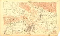
1900 Map of Los Angeles
USGS Topo · Published 1915About this map
Los Angeles River and its surrounding ranchos and canyons define this turn-of-the-century landscape, captured before the mid-century suburban expansion. The city of Los Angeles is concentrated around Elysian Park, while the northern reaches show the early foothill settlements of Burbank, Glendale, and Altadena. The era of luxury resort travel is prominent, with landmarks like the Echo Mountain Mt. Lowe Hotel, the Raymond Hotel, and the Sierra Madre Hotel serving as destinations at the edge of the Angelus National Forest.
Find a feature on this map
165 named features on this map. Tap any name to fly to it.
Don’t see what you’re looking for? This feature index may not catch every label — zoom into the map to look around manually.
Map Details
Editions of this 1900 Los Angeles Map
4 editions found

Other maps of this area

1894 · Los Angeles
USGS Topo · 1:62,500

1894 · Pomona
USGS Topo · 1:62,500

1896 · Pasadena
USGS Topo · 1:62,500

1896 · Anaheim
USGS Topo · 1:62,500

1896 · Redondo
USGS Topo · 1:62,500

1896 · Santa Monica
USGS Topo · 1:62,500

1896 · Downey
USGS Topo · 1:62,500

1897 · Pomona
USGS Topo · 1:62,500

1898 · Pomona
USGS Topo · 1:62,500

1898 · Santa Monica
USGS Topo · 1:62,500