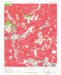
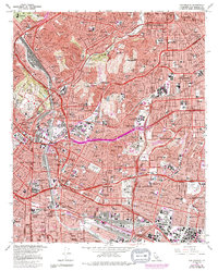
1966 Map of Los Angeles
USGS Topo · Published 1968About this map
Boyle Heights and Lincoln Heights anchor this mid-1960s view of the urban landscape, where the confluence of major infrastructure and long-standing neighborhoods is clearly defined. The Los Angeles River and Arroyo Seco serve as the primary geographical markers, though they are increasingly hemmed in by the expansive concrete network of the Golden State Freeway and the San Bernardino Freeway. This period captures the city’s dense residential growth and the prominence of institutional landmarks such as Dodger Stadium and the Southwest Museum.
Find a feature on this map
65 named features on this map. Tap any name to fly to it.
Don’t see what you’re looking for? This feature index may not catch every label — zoom into the map to look around manually.
Map Details
Editions of this 1966 Los Angeles Map
5 editions found
Other maps of this area

1894 · Los Angeles
USGS Topo · 1:62,500

1896 · Pasadena
USGS Topo · 1:62,500

1896 · Redondo
USGS Topo · 1:62,500

1896 · Santa Monica
USGS Topo · 1:62,500

1896 · Downey
USGS Topo · 1:62,500

1898 · Santa Monica
USGS Topo · 1:62,500

1899 · Downey
USGS Topo · 1:62,500

1900 · Pasadena
USGS Topo · 1:62,500

1900 · Los Angeles
USGS Topo · 1:62,500

1901 · Southern California Sheet No. 1
USGS Topo · 1:250,000