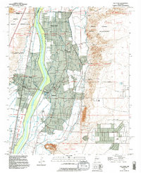
1991 Map of Los Lunas
USGS Topo · Published 1996About this map
The Rio Grande valley south of Albuquerque is defined by a dense network of irrigation infrastructure and historical land grants. This survey of the Rio Abajo region details the complex water management systems essential to the area, including the Peralta Main Canal, Belen High Line Canal, and numerous drains like the Los Chavez Drain. These waterways sustain the agricultural settlements of Bosque Farms, Peralta, and Valencia.
Find a feature on this map
44 named features on this map. Tap any name to fly to it.
Don’t see what you’re looking for? This feature index may not catch every label — zoom into the map to look around manually.
Map Details
Editions of this 1991 Los Lunas Map
This is the sole edition of this map. No revisions or reprints were ever made.
Other maps of this area

1952 · Wind Mesa
USGS Topo · 1:24,000

1952 · Dalies
USGS Topo · 1:24,000

1952 · Tome NE
USGS Topo · 1:24,000

1952 · Belen
USGS Topo · 1:24,000

1952 · Hubbell Spring
USGS Topo · 1:24,000

1952 · Tome
USGS Topo · 1:24,000

1952 · Los Lunas SE
USGS Topo · 1:24,000

1952 · Los Lunas
USGS Topo · 1:24,000

1952 · Isleta
USGS Topo · 1:24,000

1954 · Socorro
USGS Topo · 1:250,000