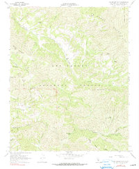
1967 Map of Los Machos Hills
USGS Topo · Published 1990About this map
Los Padres National Forest contains this mid-century view of the California interior, dominated by the La Panza Range and the Los Machos Hills. The landscape is defined by its drainage basins, with Alamo Creek and Salinas River winding through deep canyons. Settlement is sparse, represented primarily by the Avenales Ranch and supporting infrastructure like the Avenales Observation Pt and various water storage features including a Water Tank. High elevations such as Garcia Mountain overlook a network of seasonal water sources like Machesna Spring and Bluff Spring. The map documents a primitive transportation network consisting largely of Jeep Trails, serving back-country recreation at sites like Agua Escondida Campground and Paradise Campground. This survey provides a record of the remote San Luis Obispo County backcountry before later decades of management changed the local fire-lookout and ranching footprints.
Find a feature on this map
54 named features on this map. Tap any name to fly to it.
Don’t see what you’re looking for? This feature index may not catch every label — zoom into the map to look around manually.
Map Details
Editions of this 1967 Los Machos Hills Map
3 editions found
Other maps of this area

1922 · Pozo
USGS Topo · 1:62,500

1922 · Nipomo
USGS Topo · 1:62,500

1932 · La Panza
USGS Topo · 1:48,000

1935 · La Panza
USGS Topo · 1:62,500

1936 · La Panza
USGS Topo · 1:62,500

1937 · Branch Mtn
USGS Topo · 1:48,000

1942 · Branch Mountain
USGS Topo · 1:62,500

1947 · San Luis Obispo
USGS Topo · 1:250,000

1948 · San Luis Obispo
USGS Topo · 1:250,000
1952 · La Panza
USGS Topo · 1:62,500