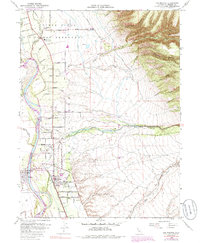
1952 Map of Los Molinos
USGS Topo · Published 1985About this map
Sacramento River waters define the western boundary of this Northern California landscape, where the flat valley floor meets the rising elevations of the Cascade foothills. The organized grid of Los Molinos and the settlement of Tehama represent the core of local activity during the early 1950s, supported by the Southern Pacific railroad corridor. The area is intersected by numerous watercourses including Antelope Creek, Dye Creek, and Mill Creek, which flows past a Diversion Dam and through the southern portion of the township.
Find a feature on this map
63 named features on this map. Tap any name to fly to it.
Don’t see what you’re looking for? This feature index may not catch every label — zoom into the map to look around manually.
Map Details
Editions of this 1952 Los Molinos Map
4 editions found
Other maps of this area

1886 · Lassen Peak
USGS Topo · 1:250,000

1890 · Red Bluff
USGS Topo · 1:250,000

1891 · Chico
USGS Topo · 1:125,000

1892 · Lassen Peak
USGS Topo · 1:250,000

1893 · Chico
USGS Topo · 1:125,000

1894 · Lassen Peak
USGS Topo · 1:250,000

1894 · Red Bluff
USGS Topo · 1:250,000

1895 · Chico
USGS Topo · 1:125,000

1904 · Vina
USGS Topo · 1:62,500

1905 · Tehama
USGS Topo · 1:62,500