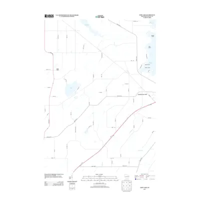
2013 Map of Lost Lake
USGS Topo · Published 2013About this map
Lost Lake and the southeastern edges of Beaver Dam Lake define this central Dodge County landscape, where agriculture and lakeside residential pockets meet. The settlement of South Beaver Dam sits near the junction of County Hwy-D and Us-151, serving as a focal point for the surrounding rural roads. To the northeast, the waters of Beaver Dam Lake are punctuated by several named landforms including Middle Island, High Island, and Poplar Island, which suggest a long-standing recreation and conservation character for the shoreline. Further south, the terrain is drained by Calamus Cr, winding through a network of section-line roads like Ridge Rd and Gunn Rd. The map illustrates a contemporary pattern of land use where historic farmstead reaches are increasingly connected by improved transit corridors like State Road 73.
Find a feature on this map
54 named features on this map. Tap any name to fly to it.
Don’t see what you’re looking for? This feature index may not catch every label — zoom into the map to look around manually.
Map Details
Editions of this 2013 Lost Lake Map
This is the sole edition of this map. No revisions or reprints were ever made.
Other maps of this area

1955 · Randolph
USGS Topo · 1:62,500

1955 · Columbus
USGS Topo · 1:62,500

1955 · Beaver Dam
USGS Topo · 1:62,500

1955 · Fox Lake
USGS Topo · 1:62,500

1957 · Madison
USGS Topo · 1:250,000

1960 · Madison
USGS Topo · 1:250,000

1975 · Beaver Dam NE
USGS Topo · 1:24,000

1980 · Fond Du Lac
USGS Topo · 1:100,000

1980 · Lost Lake
USGS Topo · 1:24,000
1980 · Columbus
USGS Topo · 1:24,000