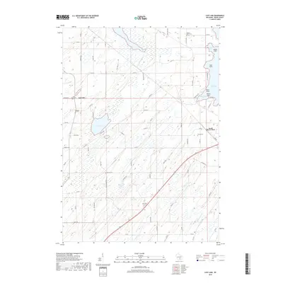
2018 Map of Lost Lake
USGS Topo · Published 2018About this map
Lost Lake and the marshy headwaters of Calamus Cr define this agricultural landscape in Dodge County. The area is marked by a high density of rural burial grounds that speak to the early settlement patterns of the township, including English Prairie Cem, Wanderers Rest Cem, and Salem Cem. Along the eastern edge, the waters of Beaver Dam Lake reach into the quadrangle at Starkweather Bay, surrounded by family-named landforms like Millers Island and Poplar Island. The small community of South Beaver Dam serves as a local hub near the intersection of Co RD D and Co RD G. A network of rural roads such as Bull Frog LN and Popular Ridge RD navigate the glacial terrain, connecting isolated farmsteads and historic church sites like Saint Marys Cem.
Find a feature on this map
68 named features on this map. Tap any name to fly to it.
Don’t see what you’re looking for? This feature index may not catch every label — zoom into the map to look around manually.
Map Details
Editions of this 2018 Lost Lake Map
This is the sole edition of this map. No revisions or reprints were ever made.
Other maps of this area

1955 · Randolph
USGS Topo · 1:62,500

1955 · Columbus
USGS Topo · 1:62,500

1955 · Beaver Dam
USGS Topo · 1:62,500

1955 · Fox Lake
USGS Topo · 1:62,500

1957 · Madison
USGS Topo · 1:250,000

1960 · Madison
USGS Topo · 1:250,000

1975 · Beaver Dam NE
USGS Topo · 1:24,000

1980 · Fond Du Lac
USGS Topo · 1:100,000

1980 · Lost Lake
USGS Topo · 1:24,000
1980 · Columbus
USGS Topo · 1:24,000